Scatterplots graph COVID-19 against income in Montreal, NYC, San francisco, and Toronto

COVID-19 case rates and socioeconomic status

Along with advancing their work on Canada's active living environment and neighborhood food environment, they also applied a health geography lens to examine the effects of the COVID-19 pandemic in Montreal.

Relationship between COVID-19 case rates and socioeconomic status

The group's interest in the social determinants of health and spatial variation in health led them to examine the relationship between COVID-19 case rates and socioeconomic status in Montreal neighborhoods.

Lab members who lead the study, developed scatterplots to visualize the data.

scatterplot to visualize the data

Preliminary results show a pattern of higher rates of COVID-19 cases in neighborhoods with lower median household income.

Urban density may play a role in contributing to the impact of COVID-19 at the neighborhood level. The pattern was similar at a broader geographic level, looking at neighborhoods in New York City and municipalities in the Greater Toronto Area.

The trend between low income and higher rates of COVID-19 suggests that the impact of COVID-19 follows a social gradient of health, meaning that people of lower socioeconomic status are more likely to become infected. Many factors—such as economic insecurity, reliance on public transportation, and poor housing conditions—may determine why low-income areas are hardest hit by COVID-19.

These scatterplots are the first step in an ongoing project that will delve into the nuances of the social determinants and spatial variations of the impact of COVID-19 in Montreal and other cities around the world.

New interactive map shows relationship between income and COVID-19 in Montreal

Building on their previous efforts to examine the relationship between income and COVID-19 in North American cities, the GeoSDH research group developed a new map of these measures in Montreal.

One side of the map shows the median household income by Montreal neighborhood, using data from the 2016 census. The other side shows the rate of COVID-19 infection per 100,000 people by neighborhood. As with the charts of dispersal to other North American cities, there is a negative trend, so lower-income neighborhoods tend to have higher rates of COVID-19 cases.

Interestingly, this map also shows that income and levels of COVID-19 vary geographically in Montreal from east to west.

Neighborhoods in the west of the island tend to have low rates of COVID-19 and high median income, while neighborhoods in the east tend to have high rates of COVID-19 and low median income.

This is a clear example of the social gradient of health and also shows that where you live and your health are often closely related.

Relationship between income and covid-19 rate in north american cities

Relationship between income and covid-19

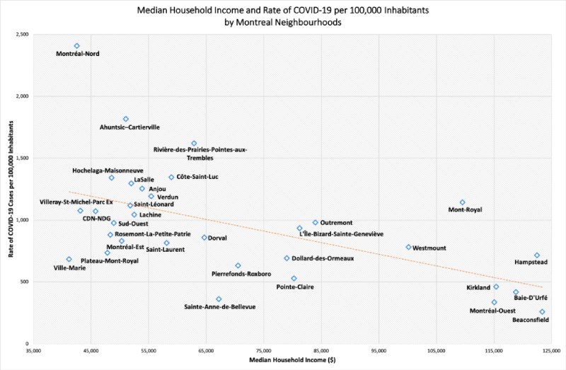
Research team members collected data and created scatterplots comparing household income and COVID-19 case rates for a large number of cities in Canada and the United States, including Toronto, Chicago, Detroit, Phoenix, Houston, Philadelphia, Miami, San Antonio and San Jose.

A consistent pattern of higher rates of COVID-19 cases was found in low-income neighborhoods in most of the cities that were studied.

In Canada, Toronto has been added at the neighborhood level. As with other cities, the general pattern is a negative relationship between the rate of COVID-19 cases per 100,000 residents and median household income. Neighborhoods with the highest rates of COVID-19 cases include Humber Heights-Westmount with 1,622 cases per 100,000 residents and Weston with 1,354 cases per 100,000 residents. The neighborhood with the lowest rate of COVID-19 cases was The Beaches with 60 cases per 100,000 residents.

Detroit stands out as the only city with a trend line showing a positive relationship between median income and the rate of COVID-19 cases per 100,000 residents. Detroit has a smaller area (138 square miles) than most of explored cities. It is possible that Detroit's small metropolitan area results in less income disparity between zip codes.

Detroit's lack of high-income zip codes may also be due to its unique pattern. In other cities, the rate of COVID-19 cases begins to decline after the median income reaches $100,000. Detroit's highest median income by zip code is $41,297, and Detroit overall is one of the economically poorest cities in the United States.

Detroit's median income is $29,481 compared to $61,937 for the entire US territory (US Census Bureau, 2018). The social gradient in health may be less visible in Detroit because the city as a whole has lower incomes, so there is generally less income inequality between neighborhoods.

These scatterplots are the first step in an ongoing project examining the spatial variation and social determinants of the impact of COVID-19 in North American cities. Many factors can affect the levels of COVID-19.

For example, Humber Heights-Westmount, one of Toronto's neighborhoods with the highest rate of COVID-19 cases, has a median income but a higher-than-average proportion of its population is elderly.